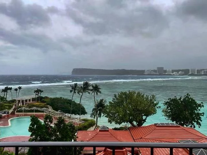
Typhoon Mawar's outer bands were whipping Guam Wednesday ahead of an expected late-afternoon or evening landfall that could devastate the US territory with deadly winds, treacherous storm surge and heavy rainfall.
Mawar's core is expected to get very near Guam -- and possibly make landfall -- around or after 4 p.m. local time on Wednesday (2 a.m. ET), and the typhoon could be the strongest storm to hit the Pacific island in more than 60 years.
By 1 p.m. local time, the storm's center was 45 miles from Guam and its maximum sustained winds were 140 mph, the equivalent of a Category 4 Atlantic hurricane, according to the National Weather Service.
In anticipation of high storm surge and potentially catastrophic coastal flooding, Guam Gov. Lou Leon Guerrero issued an executive order on Tuesday mandating the evacuation of low-lying coastal areas.
"When sea levels rise, residents will have merely minutes to evacuate and respond. Thus, we must prepare now and anticipate the worst," the governor's office said in a release.
Mawar threatens "torrential rains that may result in landslides and flash flooding, catastrophic wind, and life-threatening storm surge," the weather service said Wednesday morning.
Mawar could be the strongest storm to directly impact Guam -- home to about 150,000 people, as well as several US military installations -- since at least 1976, when Typhoon Pamela struck with sustained winds of 140 mph.
If Mawar's sustained winds are higher than 140 mph, it would be the strongest since Super Typhoon Karen, widely regarded as the worst storm to ever hit the island, which struck in 1962 with sustained winds of 172 mph.
Though Guam sits in the West Pacific Ocean -- an area prone to the world's strongest tropical cyclones -- it is extremely rare for the island to be struck directly by a storm of this strength. Only eight such storms have passed over it in the last 75 years, as hitting the approximately 30 mile-wide island amid the expansive Pacific Ocean is akin to threading a tiny needle.
15 to 20 inches of rain are possible
Mawar's slow forward pace -- about 6 mph Wednesday morning -- would exacerbate the impacts of wind and bring greater amounts of rainfall to the island than a faster-moving storm.
Storm surge of up to 25 feet above normal high tide is possible, the weather service said. That would be life-threatening and pose significant risk to vulnerable coastal areas and will likely cause severe coastal erosion. The weather service warned that even large boats could be ripped from their moorings.
Storm surge deaths are historically the leading cause of hurricane-related fatalities within the United States, according to the weather service.
The storm could bring between 15 to 20 inches of rain with even higher local amounts possible, the weather service said. The downpour will likely trigger landslides, overflow rivers and streams and bring flooding to areas that don't normally see such events.
President Joe Biden approved an emergency declaration for the island on Tuesday, and FEMA announced it has more than 50 emergency relief personnel and dozens of other federal partners ready to provide emergency assistance on the ground.
The storm is "one that will be remembered for decades," said Landon Aydlett, the warning coordination meteorologist from the weather service in Guam.
Officials have warned the storm will bring devastating impacts to the island's residents, infrastructure and landscape.
Extensive roof and structure damage is possible due to pummeling winds, especially for buildings that are not reinforced with concrete.
"Electricity and water may be unavailable for days and perhaps weeks after the storm passes" and "most trees will be snapped or uprooted," the local weather service warned.
Guam Power Authority crews had been responding to power outages and fluctuations across the island overnight Tuesday and into Wednesday, but increasingly dangerous conditions made it unsafe for personnel to be out making repairs, the utility said in a release.
"The GPA team is prepared to immediately begin restoration as soon as winds decrease to safe levels," the release reads.
Between 50 to 70 percent of Guam's vegetation could experience defoliation -- the unnatural removal of much of a plant's leaves and foliage, the weather service indicated.
Human-caused climate change is contributing to an upward trend intense storms like Typhoon Mawar. Not only are these systems generating more rainfall and larger storm surge -- they are also more likely to be stronger and are intensifying faster, CNN has reported.
Mawar rapidly intensified from Monday into Tuesday, with top wind speeds increasing by 50 mph in just 18 hours. Scientists have warned that the rapid intensification of tropical cyclones -- like typhoons and hurricanes -- is more likely as ocean temperatures climb and lay the groundwork for cyclones to explode at breakneck pace into deadly storms.

